A sweeping, bottom-up overhaul of the state of Texas’ flood control planning is underway as a result of a series of historic floods that have inundated the state over the past decade. When completed in 2024, the state’s Flood Control Plan will be a comprehensive assessment of the entire state’s flood risk and provide a prioritized list of vital projects.
“This is the first ever flood planning approach for the entire state of Texas. This is the first time that anything has been organized in this manner,” says Reem Zoun, director of flood planning for the Texas Water Development Board (TWDB),the agency tasked with developing the plan.
Public meetings to develop the regional plans began in October 2021 and to date, more than 300 have been held with hundreds of written comments being collected. The draft regional flood plans are due in August with the final versions due next January. The regional plans will then be integrated into a final statewide flood plan, due Sept. 1, 2024.
Texas Flood
A series of major flood events in the Lone Star State over the past decade proved the catalyst for the new flood plan. Multiple flooding events in 2015 caused 43 deaths and more than $1.9 billion in property damage and additional devastating floods occurred the next year.
Then, in 2017, Hurricane Harvey dropped more than 40 in. of rain on the southern coast around Houston in the span of days. That disaster claimed 68 lives, forced 39,000 people from their homes and the state amassed an estimated $125 billion in damages.
“The problem is that flooding is sporadic, it doesn't flood everywhere in Texas every year, but it usually floods somewhere in Texas every year,” said Wes Birdwell, the executive director of the Texas Floodplain Management Association.
These disasters served as a wakeup call and prompted the Texas Legislature to take action. In 2019, lawmakers directed the TWDB to create the state’s inaugural flood program. In 2007, the agency took over the state’s National Flood Insurance Program, which had been in place for more than two decades.
The key difference with the state’s effort to create a comprehensive plan for flood control is the Legislature also provided funding to begin implementing those efforts.
“It's quite exciting from an industry perspective to see this this shift from not just the upfront flood risk identification, but really on the focus to the mitigation side,” says Krista Behune Melnar, who leads Fort Worth-based Freese & Nichols’ stormwater practice.
The state created a洪水基础设施基金(FIF) in 2019 to provide financial assistance in the form of loans and grants for flood control, flood mitigation, and drainage projects. Voters subsequently approved a one-time appropriation of $793 million for the fund to be administered by TWDB. The fund can receive additional funds via legislative approval in the future.
As of late March 2022, the TWDB has committed $388 million in FIF funding to 119 projects statewide. After adoption of the first state flood plan in 2024, however, the TWDB may use the FIF only to provide financing for flood projects included in the state flood plan.
The flood control plan effort will produce detailed information on flood risk and mitigation analysis that should assist in efforts to request federal funds for projects and create a tool to better leverage those funds with state dollars through programs such as in the federal Flood Mitigation Assistance Program.
In Step
Like most other states, flood control efforts in Texas are directed by a hotchpotch of various local agencies. Since flood control was considered a local responsibility, each agency focused on flood control issues within its jurisdictional area, its access to funding and the ability to coordinate with federal agencies.
“The watersheds go from jurisdiction to jurisdiction,” says Melnar. “They don't respect political borders and so that can create complications.”
通常,使用现有联邦和州法规的框架以“自上而下”的方法制定洪水控制计划。相比之下,德克萨斯州洪水控制计划是通过关注整个流域内受影响地区的特定需求而从“自下而上”制定的。
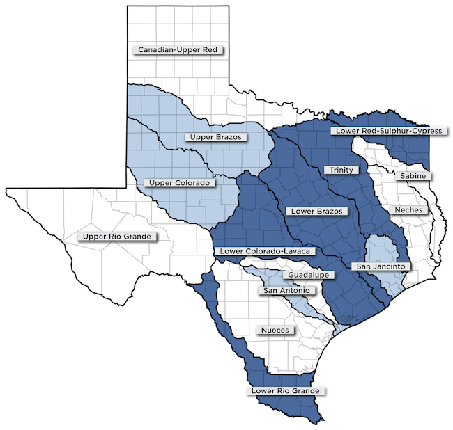
To develop the statewide flood control plan, TWDB organized the state into 15 flood control regions based on the major river watersheds across the state. Each of the local agencies within any given region participated with the formulation of the corresponding region’s plan and stakeholder input has been sought over the past year and a half.
Each region is organized as a self-governing entity or Regional Flood Planning Group (RFPG), with each group comprised of representatives from water districts, flood districts, utilities and local governments. Agricultural and environmental interests are represented along with small businesses.
 Courtesy of the Texas Water Development Board
Additionally, key state and federal agencies such as the Texas Soil and Water Conservation Board and the U.S. Army Corps of Engineers participated in the process as non-voting members.
These groups were tasked with identifying current flood mitigation strategies, evaluating local and regional flood control policies, and designating future flood mitigation projects. While the TWDB provides administrative support to the groups, each RFPG makes the decisions about the projects and infrastructure required for flood mitigation within its region.
通过让社区和机构共同努力,不能以牺牲分水岭另一部分的那些人为代价来减轻分水岭中的问题的决定。Zoun说,新的洪水控制计划要求任何项目的批准取决于证明在流域其他地方没有负面影响。
Change It
One of the first tasks for the groups involved was identifying existing infrastructure and ongoing flood mitigation projects. The next step was identifying flood risk while examining existing and future flood risk analyses. That effort was complicated by the surfeit of outdated or absent data. Typically, Federal Emergency Management Agency (FEMA) floodplain maps are more than a decade old and almost a quarter of the 254 counties across Texas lack any flood hazard information at all.
TWDB is working with FEMA and the United States Geological Survey (USGS) to develop an updated floodplain map for the entire state. By developingpublicly available, up-to-date Base Level Engineering (BLE) datasets, more detailed and accurate flood mitigation efforts can be created. TWDB hopes to have updated floodplain mapping for the entire state available by 2024.
One key point is that the plan being devised will not suddenly redraw flood maps, throwing landowners into regulatory limbo. That information, Zoun explains, will allow for greater information about flood risk, particularly for areas currently lacking any such assessment.
“This is a planning effort. It doesn't have regulatory authority. It's not changing people's floodplain,” Zoun says. “What it’s doing is giving people more information about flood risk.”
Perhaps the most important aspect of the effort to produce the statewide flood control plan is that it also includes a commitment to replicate the process every five years moving forward. This ensures that the flood risk data remains up to date and that mitigation efforts can be amended as conditions and priorities change.
Still, Birdwell says, there is an enormous amount of work to be done in order to safeguard the state from future flood events.
“Maybe twenty years from now we can begin to get our hands around this issue,” he said. “I can only hope.”